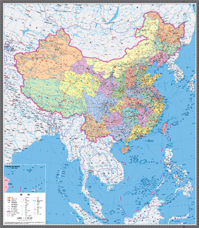
China upset many Asian countries in November by issuing a new passport that included contested South China Sea islands within its pages, and just to show you how they’ve learned from criticism, the National Administration of Surveying, Mapping and Geoinformation (NASMG) has just published, via Sinomaps Press, a new set of vertical-format maps that include more than 130 islands that didn’t appear in older editions.
According to Xinhua:
The maps will be very significant in enhancing Chinese people’s awareness of national territory, safeguarding China’s marine rights and interests and manifesting China’s political diplomatic stance, said Xu Gencai, chief editor of Sinomaps Press.
Xu added that the new vertical maps have marked clearly the major South China Sea islands and demonstrated their geographic relations with surrounding island countries as well as surrounding islands and islets.
Will the Diaoyu Islands be included?
In the bottom-left corner, there is also a zoomed illustration of the Diaoyu Islands, displaying their positional relations and those of their affiliated islets with the Chinese mainland and Taiwan.
We probably didn’t need to ask.
China publishes new maps; South China Sea islands highlighted (Xinhua)


Surprise, surprise. A rising superpower wants to fight. Never seen that before.
Danger lurks in every shoal. 2013 will be the year to watch whether China goes to war to protect its dubious island claims. There’s no limit to what a cartographer can do.
Mongolia should make a map including inner Mongolia in it’s territory. It’d be more legit!
It’s one thing to whine about “American hegemony” but it’s another to grab territory previously unclaimed until domestic political circumstance changes that.
I say bring on the ridiculous claims. I can’t wait until the Chinese are widely viewed as the world’s biggest assholes and Chinese students are sewing Japanese flags on their backpacks. It’ll take some pressure off Americans.
Why stop there? Incorporate every nation/territory that was “historically” a vassal state to the plethora of inbreeding and corrupt dynasties that molded China into what it is today.
这事要怨也怨不着土鳖共吧,谁让当年常凯申的中华冥国地图开疆开出个九段线呢,按冥国的画法土鳖共至少丢掉了三分之一的领土呢。